
Lincoln native John Schmitz began working for the railroad in 1973 as a switchman. He spent plenty of time in the "lower yard" -- an area now targeted by the city for redevelopment into an arena and other private businesses.
He was 19 when he started working on the railroad, and over the course of the next two decades, he saw how heavy rains would leave standing water in the railyard, with oil on top.
He remembers walking on dirt roads at the south end of the railyard near a junk yard that were covered with oil to suppress dust.
"Those roads were black with that oil," he said. "I walked on them. I know."
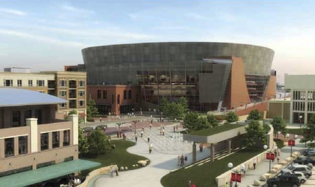
Recent talk of digging up that railyard and building roads, bridges, parking garages, shops, a hotel and a new arena has him thinking back to those days now more than ever.
People are also reading…
The cost to clean up contaminants in the railyard --and a nearby scrap yard and lumber yard -- has become a major campaign issue as the vote nears Tuesday on whether to proceed with financing on the arena project.
It's an issue with which Schmitz is still grappling as he recalls his railroad days.
Schmitz still isn't sure how he'll vote.
"It's a toughie," he says. "I think the city could use a boost. I don't know that I think this is exactly the right answer. I think all the pollution should be cleaned up. I'm not sure I want to pay for it."
However, city officials say the contamination in the development area is typical for a brownfield, an area that can be developed but first must be cleaned up.
Arena proponents say this is an opportunity for the city to clean up a polluted area, using some federal funds, and open it up to development.
The Lincoln Journal Star printing plant expansion, for example, was built on a brownfield.
The debate over whether to build a new arena to replace the half-century-old Pershing Center has focused partly on how much it would cost the city to clean up contaminants in the area it has chosen for the arena.
About half of the initial development area -- 67 of the 130 total acres -- is an active railyard used by three railroads.
Arena opponents say the current property owners, not the city, should clean up the contaminants.
State Department of Environmental Quality officials did not want to endorse the arena project but said their voluntary cleanup program is designed to facilitate the redevelopment of brownfields.
"Obviously, getting the environment cleaned up is a goal of the agency, but that's not to say we are endorsing any specific project," DEQ spokesman Brian McMannus said.
Mike Felix, supervisor for DEQ's remediation section, said the reason the department hasn't ordered the current owners to clean up the land is that a lot of the contamination probably predates state regulations, so the department wouldn't have the authority to order a cleanup.
But there are environmental issues in the development area that go beyond diesel spills. The development area is in a 100-year floodplain and is home to saline wetlands.
Here's how the city plans to deal with a plethora of environmental issues in the 130 acres west of the Haymarket:
The floodplain
Most of the arena development area is in Salt Creek's 100-year floodplain, which means the area has a 1 percent chance of a 100-year flood in any given year.
About 300 square miles drain into Salt Creek, which is adjacent to the area where the city intends to build, and the Salt Creek floodplain is about one mile wide through the area targeted for development.
Ben Higgins, senior engineer in watershed management for the city Public Works & Utilities Department, said the arena would be built 2 feet above the 500-year floodplain -- not just the 100-year floodplain, as is required of the private sector -- to reduce the risk of flooding.
That would put the arena about 1 foot higher than the downtown post office, Higgins said.
Because a lot of fill dirt will have to be brought in to build up the arena and other buildings, the city will compensate for the loss of flood storage areas by excavating dirt elsewhere to create more places for water to go during heavy rains.
City ordinance allows up to 40 percent of the floodplain to be filled, but the city intends to build the project so there is no net loss of flood storage. In other words, whatever dirt the city adds, it will excavate elsewhere.
But the city was unable to create enough flood storage in the immediate arena area, so officials plan to create more flood storage on the other side of the creek by lowering Oak Lake by 13 inches. The lake stores water pumped from Oak Creek.
In fact, Higgins said the city lowered Oak Lake last year by 13 inches to see if anybody would notice. Higgins said few people have noticed the lake is lower.
Because the city will be excavating and grading within 500 feet of the Salt Creek levees and building a bridge over Salt Creek, that work must be coordinated with the Lower Platte South Natural Resources District and the U.S. Army Corps of Engineers. Higgins said they won't OK the work until the city has final plans.
Extracting diesel from soil
The 67-acre Burlington Northern Santa Fe Railway property is just west of the Haymarket, where trains move in and out of a railyard that has been there since at least the late 1800s.
This is where almost all of the new buildings would be built: the arena, a hotel, offices, stores, condos and parking garages. And because people will be living in and visiting those buildings, by law, environmental contaminants underground must be dealt with.

Railyards are notoriously contaminated, and this one is no different. The property historically contained ice houses, turntables, repair shops and coal and lime yards.
A roundhouse, which is used to switch locomotives from one set of tracks to another using a turntable, once was located on the north side of the property; typically, hazardous materials and petroleum are handled in roundhouses.
An Environmental Protection Agency consultant recently detected elevated levels of lead northwest of the former roundhouse, which city officials plan to cap and convert into a parking lot.
The depot also is a former diesel fueling site, although fuel storage tanks were removed years ago, according to state DEQ records.
Although a diesel spill about the size of a city block is on the BNSF property northwest of Lincoln Station, the EPA testing in March did not target the soil or groundwater associated with the plume because it has been monitored and remediated since the late 1980s, when it was discovered.
BNSF slowly has been extracting diesel since then. More than 11,000 gallons of diesel fuel have been removed so far, according to DEQ records. BNSF uses a recovery well system, and if it continues to do so, it would take an estimated five to seven years to finish. However, the city plans to excavate soil and have the diesel plume cleaned up within six months.
In March, an EPA contractor, working on behalf of the city, did environmental analysis of soil and groundwater on the BNSF property and found all 18 of the subsurface soil samples contained metals, including arsenic, barium, cadmium, chromium, lead, mercury and silver.
All 18 of the samples contained levels of arsenic that exceeded state residential standards, although the average concentration for arsenic in the county is high and so it is believed to be naturally occurring arsenic.
Groundwater contaminants were detected in several samples at elevated concentrations, but Lincoln city ordinance prohibits drilling drinking water wells, so the EPA consultant's report said groundwater exposure presents minimal risk for current and proposed future use.
The report also said the risks to human health and the environment posed by the contaminants should be evaluated based on how the property is now used and would be used if developed.
Arena opponents say the city should have gone one step further and done a Phase 3 environmental study before the election. City officials say they can't do that level of study until they buy the property.
The report also indicated some concern about diesel vapor seeping into areas where people would live, work and visit -- such as the hotel, parking garage, offices and condos -- particularly in elevator shafts.
However, the city plans to remove the diesel and dirty soil and replace it with clean soil before construction.
Lumber yard
The city wouldn't be buying just railroad property for the project.
It would be buying a half-dozen parcels of land, including what is now the Watson-Brickson Lumber Yard.
In the late 1800s, the property was home to a coal gasification site, where coal was converted into natural gas, producing toxic waste that often was dumped on the property of such sites.
Coal gas sites provided most of the fuel for heating, cooking and lighting in cities from 1816 until they were replaced by natural gas in the 1950s and 1960s.
Coal tar often was spilled or buried and the waste often put in unlined pits or sometimes injected underground, contaminating soil and groundwater.
By 1928, the property had been converted into a lumber yard.
A Lincoln contractor, HWS Consulting, did Phase 1 and 2 environmental assessments of this property in 2007 and 2008.
Soil and groundwater samples from the center and southwest portions of the site had volatile organic compounds and polynuclear aromatic hydrocarbons commonly associated with former manufactured gas plants. Arsenic also was detected in shallow soils at concentrations that exceeded health benchmarks, according to the HWS report.
The lumber yard is slated to be capped and converted into parking.
Scrap yard
Adjacent to the lumber yard, the three-acre Alter Scrap Yard also has soil and groundwater contamination.
The scrap yard is targeted to be converted into green space and a District Energy Corp. power plant.
According to DEQ records, in the late 1800s, the north side of the site was used for bulk oil storage, with tanks of up to 35,000 gallons.
Until 1999, Burlington Northern Railroad owned the site and Neiden Iron and Metal operated a metal recycling facility there for about 50 years. In 1998, before Alter bought the scrap yard from Neiden, an inspection of the site showed elevated concentrations of polychlorinated biphenyl and lead and cadmium at levels that exceeded regulatory limits in the north yard.
About 350 tons of soil containing PCBs were excavated and disposed of. The soil containing lead and cadmium were treated and excavated.
HWS Consulting Group did a Phase 1 environmental site assessment at Alter in 2007 and a limited Phase 2 study in October 2008. During the Phase 2 assessment, four soil borings to a depth of 11 feet and shallow soil samples were collected. PCBs, lead and arsenic were detected in shallow soils.
The EPA consultant's report said PCBs appear to have migrated from Alter's north yard to nearby property: Four surface soil samples collected on the BNSF property adjacent to Alter by the EPA contractor in March contained reportable concentrations of PCBs.
However, the BNSF land would be developed into a road, surface parking and railroad lines.
"Future site use should be evaluated to determine if the detected concentrations of arsenic and PCBs pose a risk to human health and the environment," the recently released EPA consultant's report said.
The city is working to get access to Alter's property so an EPA contractor can do a Phase 2 assessment, but it will not be done before the election.
Union Pacific land
Union Pacific's land along the west side of the development area primarily would be used for green space.
In 2009, HWS did a Phase 1 environmental site assessment and identified a second roundhouse.
The city had planned to test soil and groundwater in 18 locations, but Union Pacific has denied access unless the city buys the land. Locations the city wants to test are near the BNSF diesel plume and near the sites of a former tannery and lead-based paint factory.
Saline wetlands
More than 20 wetlands areas are in the arena development area, including several saline wetlands. These are among the most rare in Nebraska, found only in Lancaster and Saunders counties.
They are the habitat of the endangered Salt Creek tiger beetle, although the beetles have not been found in the proposed arena development area.
City officials say none of the saline wetlands -- which have diminished in size and quality over time -- will be affected by the project; in fact, they may be restored and enhanced.
The wetlands will be protected from development by a 50-foot buffer, which will need to be widened if rare species are found.
Levees
Grading and excavating within 500 feet of the Salt Creek levees must be coordinated with the Lower Platte South NRD and the U.S. Army Corps of Engineers.
Grading for the relocated railroad tracks and parking lot would fall within that radius. The city is working on getting the necessary approval with the NRD.